


(L) Bangladesh- Population Density; (R) Bangladesh Administrative Map


(L) Bangladesh- Transport Network Map; (R) Bangladesh Rivers

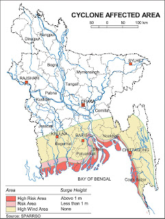
(L) Bangladesh- Flood Affected Area; (R) Cyclone affected Zone


(L) Map- Climatic Zone; (R) Map Forest zone
(map ref: http://www.bangladesh.gov.bd/)


Dhaka City map - pre Mughal period

Bengal: from '1776 Rennell / Dury Map of Bihar & Bengal (save and zoom to read)


adopted from Rennell's Map of Dhaka

Rivers East Bengal- Rennell's Map of 1776 AD

adopted from James Rennell's Map of Bengal showing Inland Navigation (1776)

Rennel's Dhaka City map of late 18th century

Dhaka City map in 1859- under British Occupation

Dhaka City Map- Capital of East Bengal and Assam during 1905-11

(L) Bangladesh- Transport Network Map; (R) Bangladesh Rivers


(L) Bangladesh- Flood Affected Area; (R) Cyclone affected Zone


(L) Map- Climatic Zone; (R) Map Forest zone
(map ref: http://www.bangladesh.gov.bd/)


Dhaka City map - pre Mughal period

Bengal: from '1776 Rennell / Dury Map of Bihar & Bengal (save and zoom to read)
- one of the first accurate maps of the interior, laid out from primary surveys done by James Rennell, the first modern cartographer to map the interior of India.


adopted from Rennell's Map of Dhaka

Rivers East Bengal- Rennell's Map of 1776 AD

adopted from James Rennell's Map of Bengal showing Inland Navigation (1776)

Rennel's Dhaka City map of late 18th century

Dhaka City map in 1859- under British Occupation

Dhaka City Map- Capital of East Bengal and Assam during 1905-11

Dhaka City Map of 1914

Dhaka City map - fag end of British rule
(map ref: Wikipedia)

Dhaka rivers and canals (daily star)

76,000 buildings in Dhaka are in high risk to a magnitude 7 earthquake,

Dhaka city Image / Googles Earth Station Map of Dhaka
http://www.nationsonline.org/oneworld/map/google_map_Dhaka.htm

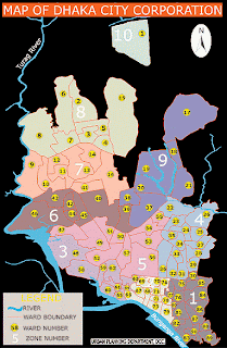
L: Dhaka Map of RAJUK website---R: Dhaka City Divide (N & S)
 DAP (Detailed Area Plan) area is 1528 sq. km or 590 sq. miles which covers the total RAJUK's jurisdiction area, plus
Mapping of Bengal:
James Rennell (1742-1830) was born in Devonshire, England became a geographer and marine engineer and made an exploration of the Bengal river basins and mapped them for the first time. To facilitate commercial navigation, Henry Vansittart, governor of the Fort William, Calcutta gave him a commission in Bengal Engineers of the Company's army and entrusted him with the specific responsibility of making a survey of the major rivers of Bengal and their tributaries. After the company's acquisition of the Diwani of Bengal, Bihar and Orissa (1765), the need for such a survey was more keenly felt. Governor Robert Clive thus established a regular survey department in 1767 with James Rennell as its Surveyor General.
By the time, of course, Rennell had largely completed his explorations of the Ganges, Brahmaputra and Meghna river-systems. Dhaka was his operational headquarters. Originally, Rennell was employed for only surveying the Ganges delta with the special objective of finding a shorter passage suitable for large vessels from the Ganges to Calcutta, than that through the Sundarbans and the Meghna. His daily journal gives a detailed account of this voyage and of three subsequent expeditions, during which he surveyed greater part of northern and eastern Bengal, penetrating beyond Goalpara in Assam. Inadequately equipped, he was attacked by tigers, reptiles, dacoits and hostile people many times as he completed the survey within a span of three years with the help of only four assistants. It was while he was engaged on this duty on the frontier of Kuch Behar that he was attacked and severely wounded by a party of the rebellious followers of Fakir Majnu Shah.
His expeditions were so satisfactorily made that later the Survey of India found his identifications remarkably accurate. To all users — academic, administrative and navigational, Rennell's Atlas was the dependable guide until professional maps were made available in mid 19th century. Rennell's second great work was the first approximately correct map of India. The map was accompanied by a Memoir (1783) containing a full account of the plan on which it was executed. Rennell retired from the service in 1776 shortly after being promoted to the rank of Major in the Bengal Engineers. His Bengal Atlas, published in 1779, was a work of the highest importance from commercial, military and administrative points of view. To all users - academic, administrative and navigational, Rennell's Atlas was the dependable guide until professional maps were made available in mid 19th century (ref: Banglapedia).
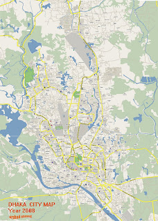
It's a pity that Government, Tourism (Parjatan corp) or Dhaka City Corporation has yet to come up with interactive digital map of Dhaka city with images, landmarks and road networks- 'ward by ward'. The Dhaka city maps commercially printed by private firms "The Mappe" or "Graphosman"is too concise and do not show details of road network and landmarks of greater Dhaka.

Dhaka City map - fag end of British rule
(map ref: Wikipedia)

Dhaka rivers and canals (daily star)

76,000 buildings in Dhaka are in high risk to a magnitude 7 earthquake,


Dhaka city Image / Googles Earth Station Map of Dhaka
http://www.nationsonline.org/oneworld/map/google_map_Dhaka.htm


L: Dhaka Map of RAJUK website---R: Dhaka City Divide (N & S)

- Gazipur Municipality to the North
- Dhaleshawri River to the south
- Bangshi and Dhaleshawri River to the west
- Shitalakkhya and Meghna River to the East
Mapping of Bengal:
James Rennell (1742-1830) was born in Devonshire, England became a geographer and marine engineer and made an exploration of the Bengal river basins and mapped them for the first time. To facilitate commercial navigation, Henry Vansittart, governor of the Fort William, Calcutta gave him a commission in Bengal Engineers of the Company's army and entrusted him with the specific responsibility of making a survey of the major rivers of Bengal and their tributaries. After the company's acquisition of the Diwani of Bengal, Bihar and Orissa (1765), the need for such a survey was more keenly felt. Governor Robert Clive thus established a regular survey department in 1767 with James Rennell as its Surveyor General.
By the time, of course, Rennell had largely completed his explorations of the Ganges, Brahmaputra and Meghna river-systems. Dhaka was his operational headquarters. Originally, Rennell was employed for only surveying the Ganges delta with the special objective of finding a shorter passage suitable for large vessels from the Ganges to Calcutta, than that through the Sundarbans and the Meghna. His daily journal gives a detailed account of this voyage and of three subsequent expeditions, during which he surveyed greater part of northern and eastern Bengal, penetrating beyond Goalpara in Assam. Inadequately equipped, he was attacked by tigers, reptiles, dacoits and hostile people many times as he completed the survey within a span of three years with the help of only four assistants. It was while he was engaged on this duty on the frontier of Kuch Behar that he was attacked and severely wounded by a party of the rebellious followers of Fakir Majnu Shah.
His expeditions were so satisfactorily made that later the Survey of India found his identifications remarkably accurate. To all users — academic, administrative and navigational, Rennell's Atlas was the dependable guide until professional maps were made available in mid 19th century. Rennell's second great work was the first approximately correct map of India. The map was accompanied by a Memoir (1783) containing a full account of the plan on which it was executed. Rennell retired from the service in 1776 shortly after being promoted to the rank of Major in the Bengal Engineers. His Bengal Atlas, published in 1779, was a work of the highest importance from commercial, military and administrative points of view. To all users - academic, administrative and navigational, Rennell's Atlas was the dependable guide until professional maps were made available in mid 19th century (ref: Banglapedia).
It's a pity that Government, Tourism (Parjatan corp) or Dhaka City Corporation has yet to come up with interactive digital map of Dhaka city with images, landmarks and road networks- 'ward by ward'. The Dhaka city maps commercially printed by private firms "The Mappe" or "Graphosman"is too concise and do not show details of road network and landmarks of greater Dhaka.
26 comments:
I am from India..Thanks for the wonderful story of Rennel's adventure and mapping of India.
Can you refer a site where from can I get road map showing drive direction and parking space to navigate around Dhaka.
Thanks for posting very useful map of Dhaka city.
Many thanks for the comment on my Dhaka article at All Things Pakistan. Your blog has some amazing pictures and before I go to Dhaka the next time, I would take note of all these lovely places and visit them.
best
:)
thanks raza rumi, you are most welcome.
great collection of maps. many many thanks.
very very useful maps. thanks for posting.
Outstanding source of information for all the Desi people.I'm very impressed, thanx a million !
This is really an outstanding job!! Thanks a lot, was looking for these maps for my PhD thesis and got here. Thanks again -
Imtiaz, Amsterdam
isaikh@fmg.uva.nl
Just to add with my previous comment. It would be really very much helpful for researchers like me if you kindly state original sources of these maps as references.
Dear Mr.Ahmed,
I've been visiting your site for past few days. It's an wonderful site full of information.
I'm from West Bengal, India.
Seems that you're an ardent Dhaka lover, I've visited that city twice but that couldn't quench my thirst of visiting it again, particularly old Dhaka. It's simply fabulous.
I'm interested in the geography of Bengal. Could you please tell me from where you've collected Rennell's inland navigation map? Following your reference I've searched Wikipedia but couldn't locate it. Secondly, the map seems to be revised, could you give me the reference from where I can get the original one?
Thanking you, have done a great job.
With regards
Arun K.Nag
Dear Mr. Nag.
Thanks so much for your comments and appreciation of old Dhaka.
Rennell's map was found with a japanese Consulting Firm working here in river study for ports early in the '90s.
Later, I tried in the internet, but could not find this particular one.
Regards,
Ershad Ahmed
Hi, Thanks for the maps.I m Glad 2 u.i got the 011-%2BDhaka%2BCity%2Bmap%2B2006 map.but i have not found of the maps clear version.i cant see it very clearly.So, Could u plz send me of the map Clear rejulation........
my Email id is jubair82@gmail.com
thanks fro all
Thanks for the Dhaka city map{011-%2BDhaka%2BCity%2Bmap%2B2006). i m glad to you.But i need more rejulation to see it clearly.So could u please send me the map copy at me E-mail address....
jubair82@gmail.com
Thanks for all
Thanx man,
Its wonderful collection
I am staying In Dhaka city from last
15 years but i wasn't Know lots about Dhaka. Thanks again u rich my knowledge about Dhaka
Salaam
Great work Ershad Chacha! Kudos on some excellent public service. I look forward to coming back to re-live more of my beloved Dhaka. These maps will come in very useful indeed.
Thanks for visiting the site.
Ershad Ahmed
Thank you Ershad bhai. I found your webpage by browzing. Really interesting and well-made topics. However, the most I liked is the Dhaka city's history in map. Thanks once again for making this webpage. Mahmood
Dear Mr. Ershad,Thank you very much for this valuable contribution to expanding research in history, & geography of Bangladesh.
A.H.Sadique, Rtd. Principal Secretay to B.D Govt.
Gulshan , Dhaka
31-05-08.
Thanks so much.
Many many thanks for the collection of your website. Itz really helpful :)
Sir Irshad Ahmed, this website is fully knowledge & Informations of Bangladesh and very nice pics of Dhaka city and history of Bangladesh.
Realy Its a Great Efforts you hv been done.
Great Salute To Sir Irshad Ahmed.
anwer hashim from Karachi
Thanks for the maps. it was very useful.
Souman , Uk
can any one plz give me a map of internal water body map of dhaka city......plzzzz
It's awesome designed for me to have a web site, which is useful in favor of my knowledge. thanks admin
My web blog: Mesothelioma Charitiy
Nice blog! I am visiting first time on your blog and it’s looking Amazing.
Thanks for your nice post.We received a clear sense of Dhaka city from these maps.
Post a Comment